
- Highlights: Waterfalls, Appalachian Trail, river views
- Distance: 6.5 mile loop
- Elevation Change 1,492 feet
- Trail Surface: Dirt with numerous rocky sections
- Difficulty Level: Strenuous (elevation change, rocky trail surface)
- Trailhead Parking: Big Meadows Amphitheater, near Big Meadows Picnic Ground
- Website: AllTrails and Shenandoah National Park
- Beer Pairings: Big Meadows Lodge/Basic City Brewery—Big Meadows IPA & Bearfence DIPA
Trail Map:
The Hike:
We have hiked to both Dark Hollow Falls and Rose River Falls and they are both great hikes. This hike combines both falls and includes a short stretch on the Appalachian Trail. Note pets are not allowed at Dark Hollow Falls. Navigating through the campground at the beginning of the hike can be a bit confusing. Either download the AllTrails map or stop at the park Visitor Center for a trail map.
This hike begins at the Big Meadows Amphitheater. We chose to hike counterclockwise. AllTrails suggest a clockwise route, but either direction will work. Follow the loop road either way to Big Meadows Picnic Road and then turn left at the Campground Office. Stop here and ask a friendly ranger for directions to the Nature Trail.
If the office is closed, continue past the office and take the first right to “Big Meadows Loop A”. Follow the paved road through the campground on Loop A and at campsite # 18 take an unpaved path on the right. The path leads to the blue-blazed Story of the Forest Trail.
The Story of the Forest Trail has several signs describing the flora and fauna of the forest in SNP. Pass an air quality monitoring station on the right and continue straight at several trail junctions. Reach Skyline Drive at 1.2 miles.
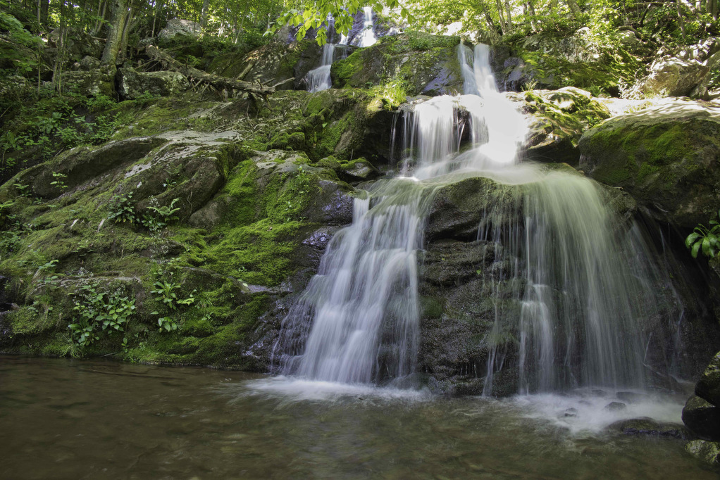
Dark Hollow Falls
Cross Skyline Drive and follow the blue-blazed Dark Hollow Falls trail on the left. The paved trail quickly ends and the trail soon begins a steep and rocky descent. Numerous sets of steps and switchbacks help with the climb down to the falls. Hogcamp Branch soon joins the trail on the right and in the summer the flow of water may be diminished.
Reach the first view of the falls at 1.8 miles. A series cataracts and pools are formed by this cascading 70’ waterfall. Watch your footing as the rocks are typically wet and slippery. Continue down the trail past more small pools and cataracts and reach bridge and trail junction. On the right are some nice views of the lower falls. The bridge crosses Hogcamp Branch and then meets the blue-blazed Rose River Falls Loop trail on the left.
Rose River Falls
Bear left on the Rose River Loop Trail toward Fishers Gap. The trail follows the stream and sections of the trail become very rocky. More small cataracts and pools are formed by the stream with easy access from the trail.
A metal footbridge crosses Hogcamp Branch and then rock-hop over a small stream. Pass the remains of an abandoned copper mine. A few stoneworks are all that remain of this mine from the early 1900s. Continue on the trail and the Rose River soon joins on the right.
Sections of this trail are rocky and steep as you climb to the falls. Reach Rose River Falls at 3.6 miles. This 67’ waterfall forms a small pool and a steep spur trail leads to the bottom of the falls.
Continue the climb as the trail parallels the river. Several pools are home to brook trout and this area is a popular fishing hole.
The trail soon leaves the river but the climb up continues. The trail joins the yellow-blazed Skyland-Big Meadows Horse Trail. Stay left on the combined trail to reach the Rose River Fire Road. Bear right here and cross Skyline Drive.
Appalachian Trail
Stay to the right after crossing the road and enter a hiker parking lot (not the parking area for Fishers Gap which is on the left). Follow the parking area and meet the Appalachian Trail at the end of the parking area near the fire road gate. Bear left and follow the white-blazed AT southbound for 1.5 miles.
Reach an open area with nice views to the west before entering the forest. In the summer months, ferns and wildflowers line the trail. The Big Meadows campground is on the left at 5.7 miles. Stay right and continue on the AT as it skirts around campsites. At 6.3 miles, look for a cement trail post with a white blaze. Turn left here leaving the AT. There is a short paved section of the trail which leads to the Amphitheater and Picnic Area.
Hike Photos:
Click on an image below for an enlarged view.


Beer Pairing:
Big Meadows Lodge is located just a few hundred yards from the amphitheater via a paved path. When you finish the hike and exit the AT, continue to the paved road near the amphitheater. Bear right on the road and in about 100 yards take the paved path on the right which leads to the Lodge.
The New Market Taproom at Big Meadows Lodge has a nice selection of craft beer and they serve a variety of food. They have indoor and outdoor seating with some great views from the outdoor patio. It’s a perfect spot to relax after a hike with a cold beer.
Basic City Brewery in Waynesboro (and Richmond) has been one of our favorites for many years. They make several specialty beers for Shenandoah National Park including Big Meadows IPA & Bearfence DIPA. Both beers came in cans; however, the taproom does have a nice selection of craft beers on draft. Big Meadows IPA was nicely hopped and Bearfence had an extra boost of hops and alcohol.


Hike and drink responsibly. Never drink and drive. Stay safe, be responsible, and leave no trace.