Kid Friendly

Dripping Rock to Cedar Cliffs AT

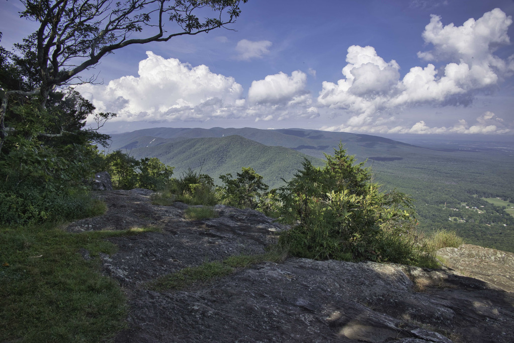
Highlights: Great views, Appalachian Trail Distance: 2.3 miles out and back Elevation Change: 245 feet Trail Surface: Dirt with rocky sections Difficulty Level: Easy (rocky sections) Trailhead Parking: Dripping Rock, Blue Ridge Parkway MP 9.6 Website: AllTrails https://www.alltrails.com/explore/trail/us/virginia/dripping-rock-south-via-appalachian-trail Beer Pairings: Stable Craft Brewing—Shenny Doah Pilsner & Robot Cowboy Hazy IPA The Hike: This short hike […]

Dripping Rock to Cedar Cliffs AT Read More »

Fort Monroe Seawall

Highlights: Fort Monroe, Chesapeake Bay views Distance: 3.4 miles out and back Elevation Change: 36 feet Trail Surface: Paved Difficulty Level: Easy (smooth surface, no elevation gain) Trailhead Parking: Fort Monroe Visitor & Education Center, 30 Ingalls Rd, Fort Monroe, VA Website: AllTrails and National Park Service Beer Pairings: 1865 Brewing Co.—High Noon Pale Ale

Fort Monroe Seawall Read More »

Rice Fields AT Shelter

Highlights: Mountain meadow, AT shelter, great views Distance: 5.2 miles out and back Elevation Change: 1,259 feet Trail Surface: Rocky Difficulty Level: Moderate (rocky surface, elevation gain) Trailhead Parking: From Blacksburg US 460 west, turn left on Route 641, in 1.5 miles turn left on to Pocahontas Road. In 150 yards reach the AT crossing

Rice Fields AT Shelter Read More »

Cascade Falls Loop

Highlights: Waterfalls, Little Stony Creek Gorge Distance: 4.0 mile loop Elevation Change: 700 feet Trail Surface: Rocky Difficulty Level: Easy/moderate (rocky surface, elevation gain) Trailhead Parking: Cascades Day Use Parking Area, route 623 in Pembroke VA; $3 parking fee required Website: AllTrails and US Forest Service Beer Pairings: Eastern Divide Brewing Co.—Czech Pilsner & Cliffhanger

Cascade Falls Loop Read More »

White Rock Falls

Highlights: Waterfalls, mountain views Distance: 4.4 mile loop Elevation Change: 886 feet Trail Surface: Dirt with several rocky sections Difficulty Level: Moderate (elevation)  Trailhead Parking: White Rock Gap parking area, Blue Ridge Parkway mile post 18.5 Website: AllTrails Beer Pairings: Brewing Tree Brewing Co.—Chapter 2 IPA & Flip Flop Pils The Hike: Most people like

White Rock Falls Read More »

Buzzard Rock

Highlights: Great views, rocky summit Distance: 4 miles out and back Elevation Change: 631 feet Trail Surface: Very rocky Difficulty Level: Easy/moderate (rocky surface)  Trailhead Parking: Buzzard Rock Trailhead, 3094 Mountain Road, route 619, Lake Frederick VA Website: AllTrails Beer Pairings: PaveMint Smokin’ Taphouse—Lionshead Pilsner & Hazy Tides IPA The Hike: Buzzard Rock is located

Buzzard Rock Read More »

Little Flat Mountain

Highlights: Wildflowers, streams, mountain views Distance: 4.5 mile loop Elevation change: 1,263 feet Difficulty level: Moderate/strenuous Trailhead Parking: Patricia Ann Byrom Forest Preserve Park, 6610 Blackwells Hollow Road, Crozet, VA  Website: Albemarle County and AllTrails Beer Pairings: Skipping Rock Beer Co. Amber Lager & Bell’s Brewery Two Hearted Ale The Hike: This fun hike is

Little Flat Mountain Read More »

Highland Mountain Trail

Highlights: History, wildlife, wildflowers Distance: 3.6 mile loop Elevation change: 558 feet Difficulty level: Easy/Moderate Trailhead Parking: Highland, 2050 James Monroe Parkway, Charlottesville Website: James Monroe Highland Beer Pairings: Decipher Brewing Co.—Scytale Stout & Broken Logic IPA The Hike: We have had several requests for shorter, easier hikes. This short hike travels to the top

Highland Mountain Trail Read More »

Saunders-Monticello Trail

Highlights: Wildflowers, history Distance: 4.3 miles out and back Elevation change: 238 feet Difficulty level: Easy Trailhead Parking: Monticello, 931 Thomas Jefferson Parkway; alternate parking area at Kemper Park; no entry fee required for trail use Website: Monticello Beer Pairings: Random Row Brewing Co.—Eagle Swoop Bitter & DoMo Triple IPA The Hike: We have had

Saunders-Monticello Trail Read More »

Bassett Trace Nature Trail

Highlights: Nature trail, lake views, bird watching Distance: 2.9 miles out and back Elevation change: 265 feet Difficulty level: Easy Trailhead Parking: Griffin Hotel, 136 E. Francis Street, Williamsburg Website: Colonial Williamsburg Beer Pairings: Precarious Beer—Fortune and Glory Pilsner & Chug Rug IPA The Hike: Located near Bassett Hall and owned by Colonial Williamsburg, this

Bassett Trace Nature Trail Read More »