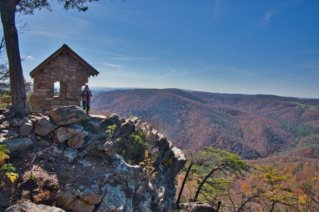
bird watching

AT: Cross Mountain & Osborne Farm

Trail Map: The Hike: This hike is an easy walk on the Appalachian Trail through mountaintop pastures, with scenic views of surrounding mountains. A half-mile section of the trail is ADA compliant and wheelchair accessible. The AT winds through several pasture areas before entering the forest at just under one mile.  We were greeted at […]

AT: Cross Mountain & Osborne Farm Read More »

Alum Cave Bluff Trail

Trail Map: The Hike: We arrived before 8am on a Tuesday in mid-May and parking was filling up quickly. GSMNP charges a $5 per day parking fee. This parking area doesn’t sell parking permits, we purchased one at the Sugarlands Visitor Center. This is a popular hike and parking areas fill up quickly. The trail

Alum Cave Bluff Trail Read More »

Hawks Ridge Loop

Trail Map: The Hike: This hike passes through a small part of the 40,000 acres of Cheat Mountain which joined the Monongahela National Forest in the 1980s. Before being rescued by the Forest service, logging companies cut down most of the trees and strip mines devastated the landscape. The high, wide-open landscape has been nicknamed

Hawks Ridge Loop Read More »

Hanging Rock (WV) Observatory

The Hike: This short hike has some great views with minimal hiking effort. Located in the Potts Creek Wildlife Management Area in West Virginia, this hike climbs up Peters Mountain on the Eastern Continental Divide to a raptor observatory. The hike travels along the Allegheny Trail a 311-mile long trail stretching from Pennsylvania to West

Hanging Rock (WV) Observatory Read More »

Shenandoah River State Park Loop

The Hike: Shenandoah River State Park is located just across US 340 from its national park cousin. The park has 5 miles of Shenandoah River South Fork shoreline and over 25 miles of hiking trails. We visited on a rainy day in late March when the Virginia bluebells were at their peak. This loop hike

Shenandoah River State Park Loop Read More »

Machicomoco State Park

The Hike: Machicomoco is one of Virginia’s newest State Parks. This small park (645 acres) is home to diverse wildlife habitats, from open fields to woodlands and waterfront/marsh areas. The park is still a bit of a work in progress as more trails and facilities are planned. The park currently has three hiking trails. Our

Machicomoco State Park Read More »

Eagle Rock

Highlights: Great views, Tuscarora Trail Distance: 2.2 miles out and back Elevation Change 489 feet Trail Surface: Mostly dirt with a few rocky sections Difficulty Level: Easy/Moderate (some rocky sections) Trailhead Parking: Eagle Rock Trailhead parking area at the VA/WV state line, Capon Springs Grade, search Google Maps for “Tuscarora Trail Eagle Rock Trailhead” Website:

Eagle Rock Read More »