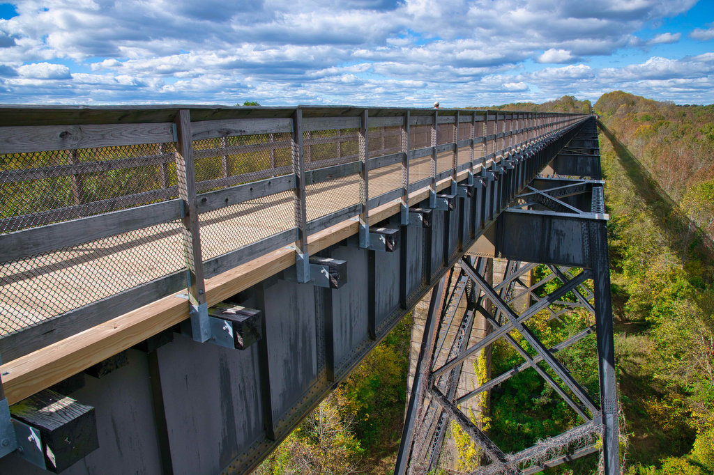
fall foliage

High Bridge Trail

Highlights: Historic High Bridge, civil war earthworks, Appomattox River Distance: 8.2 mile out and back Elevation change: 270 feet Difficulty level: Easy/moderate Trailhead Parking: High Bridge Trail State Park, Camp Paradise parking area, 1466 Camp Paradise Road; Rice, VA, park fee required. Website: High Bridge Trail State Park Beer Pairings: Three Roads Brewing Co.—Drive By […]

High Bridge Trail Read More »

Bearfence Rock Scramble

Highlights: Fantastic views, rock scramble, Appalachian Trail Distance: 1.1 mile loop Elevation change: 217 feet Difficulty level: Moderate with rock scramble, easy without the scramble Trailhead Parking: Skyline Drive Bearfence Trailhead parking area mile 56.4, park fee required Website: Shenandoah National Park Beer Pairings: Octonia Stone Brew Works—Rokuhnite Me Amadeus lager & Worth One’s Basalt

Bearfence Rock Scramble Read More »

South River Falls Loop

Highlights: Waterfalls, wildflowers, Appalachian Trail Distance: 4.9 mile loop Elevation change: 1,081 feet Difficulty level: Moderate Trailhead Parking: Skyline Drive South River Picnic Area mile post 63, park fee required. Park near the rest rooms at the far end of the picnic grounds. Website: Shenandoah National Park Beer Pairings: Patch Brewing Co.—Home Field Advantage porter

South River Falls Loop Read More »

Crabtree Falls to The Priest

Highlights: Views, wildflowers, wildlife, waterfalls, Appalachian Trail Distance: 10.5 miles out and back Elevation change: 2,570 feet Difficulty level: Strenuous Trailhead Parking: Crabtree Falls Trailhead parking area, Route 56, Tyro VA, $3 parking fee Website: AllTrails Beer Pairings: Blue Mountain Barrel House—Red Zeppelin Red IPA & Classic Lager The Hike: The Priest is a famous

Crabtree Falls to The Priest Read More »

Thornton River Loop

Highlights: Appalachian Trail, stream crossings, wildflowers, history Distance: 7.8 miles loop Elevation change: 1,780 feet Difficulty level: Strenuous Trailhead Parking: Skyline Drive Thornton River Trailhead parking area mile 25.4, park fee required Website: AllTrails Beer Pairings: Iron Pipe Aleworks—Shapeshifter IPA & Gandalf the Haze IPA  The Hike: This hike doesn’t have amazing views or spectacular

Thornton River Loop Read More »

Dragon’s Tooth

Highlights: Great views, Appalachian Trail, rock scrambles, wildflowers, Triple Crown Distance: 5.5 miles loop Elevation change: 1,340 feet Difficulty level: Strenuous Trailhead Parking: Dragon’s Tooth Trailhead, route 311 Website: Visit Roanoke and Hiking Upward  Beer Pairings: A Few Old Goats Brewing—Oatmeal Stout & Galactic Retribution IPA  The Hike: Dragon’s Tooth was our 3rd Triple Crown

Dragon’s Tooth Read More »

Tinker Cliffs

Highlights: Great views, Appalachian Trail, wildflowers, Triple Crown Distance: 7.5 miles out and back Elevation change: 1,810 feet Difficulty level: Strenuous Trailhead Parking: Andy Layne Trail Parking, Catawba Road route 779 Website: Visit Roanoke and AllTrails Beer Pairings: Parkway Brewing Co.—Triple A Red Ale & Grapefruit Get Bent Mountain IPA  The Hike: Tinker Cliffs is

Tinker Cliffs Read More »

Rock Castle Gorge

Highlights: Great views, meadows, cascades, wildflowers, birdwatching, historic buildings Distance: 11.2 mile loop Elevation change: 2,226 feet Difficulty level: Strenuous Trailhead Parking: CC Camp Lane route 605, Floyd VA; alternate trailhead Blue Ridge Parkway mile 168, Saddle Overlook parking area Website: Hiking Upward and Blue Ridge Parkway, National Park Service Beer Pairings: Buffalo Mountain Brewery—McDaniel’s

Rock Castle Gorge Read More »

Three Ridges: Reeds Gap to Tye River

Highlights: Great views, Appalachian Trail, wildflowers, stream crossings Distance: 10.8 miles one way Elevation change: 2,231 feet Difficulty level: Strenuous Trailhead Parking: Reeds (Reids) Gap, Beech Grove Road, route 664 and Blue Ridge Parkway Website: AllTrails Beer Pairings: Wild Wolf Brewery—Nelsonite Brown Ale & Notorious H.O.P. IPA The Hike: Several of our friends have hiked

Three Ridges: Reeds Gap to Tye River Read More »

Fortune’s Cove Preserve

Highlights: Mountain views, wildlife, wildflowers, stream crossings Distance: 3.7 miles loop Elevation change: 790 feet Difficulty level: Easy/Moderate Trailhead Parking: Route 651, Fortune’s Cove Lane, Lovingston VA Website: Fortune’s Cove Preserve  Beer Pairings: Wood Ridge Farm Brewery—Hop Notch IPA & Mr. Brown Stout The Hike: Fortune’s Cove is a hidden gem located about 40 miles

Fortune’s Cove Preserve Read More »